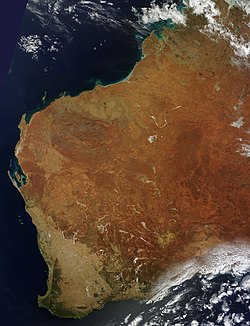
ؤسطراليا دلغرب

ويلاية ديال ؤسطراليا


ؤسطراليا دلغرب (بالنݣليزية: South Australia) هي وحدة من لويلايات ديال ؤسطراليا. كاتسمى "لويلاية الدهبية" (بالنݣليزية: The Golden State)، ولعاصيمة ديالها هي پيرت. ؤسطراليا دلغرب فيها رابع أكبر عدد ديال الناس، واللي واصل لجوج دلمليون و474 ألف واحد ف2016.[2] لميساحة ديال ؤسطراليا دلغرب هي 2,527,013 كم².[3]

Western Australia (en)
ؤسطراليا دلغرب
التقسيم لإداري
لبلاد ؤسطراليا
لعاصيمة پيرت
لأقاليم
City of Albany
City of Armadale
City of Bayswater
City of Belmont
City of Bunbury
City of Canning
City of Cockburn
City of Fremantle
City of Geraldton-Greenough
City of Greater Geraldton
City of Gosnells
City of Joondalup
City of Kalgoorlie-Boulder
City of Mandurah
City of Melville
City of Nedlands
City of Perth
City of Rockingham
City of South Perth
City of Stirling
City of Subiaco
City of Swan
City of Wanneroo
Shire of Ashburton
Shire of Augusta-Margaret River
Shire of Beverley
Shire of Boddington
Shire of Boyup Brook
Shire of Bridgetown-Greenbushes
Shire of Brookton
Shire of Broome
Shire of Broomehill-Tambellup
Shire of Bruce Rock
City of Busselton
Shire of Capel
Shire of Carnamah
Shire of Carnarvon
Shire of Chapman Valley
Shire of Chittering
Shire of Collie
Shire of Coolgardie
Shire of Coorow
Shire of Corrigin
Shire of Cranbrook
Shire of Cuballing
Shire of Cue
Shire of Cunderdin
Shire of Dalwallinu
Shire of Dandaragan
Shire of Dardanup
Shire of Denmark
Shire of Derby-West Kimberley
Shire of Donnybrook-Balingup
Shire of Dowerin
Shire of Dumbleyung
Shire of Dundas
Shire of East Pilbara
Shire of Esperance
Shire of Exmouth
Shire of Gingin
Shire of Gnowangerup
Shire of Goomalling
Shire of Halls Creek
Shire of Harvey
Shire of Irwin
Shire of Jerramungup
City of Kalamunda
Shire of Katanning
Shire of Kellerberrin
Shire of Kent
Shire of Kojonup
Shire of Kondinin
Shire of Koorda
Shire of Kulin
Shire of Lake Grace
Shire of Laverton
Shire of Leonora
Shire of Manjimup
Shire of Meekatharra
Shire of Menzies
Shire of Merredin
Shire of Mingenew
Shire of Moora
Shire of Morawa
Shire of Mount Magnet
Shire of Mount Marshall
Shire of Mukinbudin
Shire of Mullewa
Shire of Mundaring
Shire of Murchison
Shire of Murray
Shire of Nannup
Shire of Narembeen
Shire of Narrogin
Shire of Ngaanyatjarraku
Shire of Northam
Shire of Peppermint Grove
Shire of Perenjori
Shire of Pingelly
Shire of Plantagenet
Shire of Quairading
Shire of Ravensthorpe
City of Karratha
Shire of Sandstone
Shire of Serpentine-Jarrahdale
Shire of Shark Bay
Shire of Tammin
Shire of Three Springs
Shire of Toodyay
Shire of Trayning
Shire of Upper Gascoyne
Shire of Victoria Plains
Shire of Wagin
Shire of Wandering
Shire of Waroona
Shire of West Arthur
Shire of Westonia
Shire of Wickepin
Shire of Williams
Shire of Wiluna
Shire of Wongan-Ballidu
Shire of Woodanilling
Shire of Wyalkatchem
Shire of Wyndham-East Kimberley
Shire of Yalgoo
Shire of Yilgarn
Shire of York
Town of Bassendean
Town of Cambridge
Town of Claremont
Town of Cottesloe
Town of East Fremantle
City of Kwinana
Town of Mosman Park
Town of Narrogin
Town of Port Hedland
Town of Victoria Park
City of Vincent
Shire of Northampton
Shire of Nungarin
التأسيس 1829
تسمات على ؤسطراليا و غرب
لجغرافيا والسكان
لميساحة 2,527,013 كم²
بلاصة لعالية جبل ميهاري (1,251 م)
محادية معا ؤسطراليا دلجانوب
لأرض دالشمال
شحال دالسكان 2,656,156 (2020)
لإدارة
كريس داوسون
لوزير اللول ديال ؤسطراليا دلغرب روجر كوك
معلومات خرى
التوقيت ڭرينيتش + 8
Australia/Perth
اللوغات
السيت الرسمي لموقع الرسمي[1]
كود إيزو 3166-2 AU-WA
خريطة لجيهة


لموقع ولموناخ بدل

كاينة ؤسطراليا دلغرب فلغرب ديال لبلاد. هاد لويلاية داير بيها لأرض دالشمال و ؤسطراليا دلجانوب من جيهة الشرق، ولمحيط لهندي من جيهة لغرب. الطول ديال لبحورة دؤسطراليا دلغرب واصل ل20781 كيلوميطر.[4] لوسط ديال لويلاية فيه لمناطيق الناشفة، وماكاطيحش فيها بزاف ديال الشتا. الشمال ولجانوب لغربي ديال لويلاية هوما اللي كاطيح فيهوم الشتا، اللي تقدر توصل فالشمال ل1500 ملم. التلج قليل فبن كايطيح وإلا طاح ماكايفوتش 5 سنتيمتر وماكايدوزش نهارو.[5] أعلى درجة تسجلات فؤسطراليا دلغرب هي °50.5 فمحطة ماردي نهار 19 فبراير 1998. أقل درجة ديال لحرارة تسجلات كانت وصلات ل °7.2 − فلمرصاد لفلكي ديال آي بيرد نهار 17 غشت 2008.[6]

السكان بدل

لمدينة السكان
پيرت 2,043,138[7]
بونبوري 73,989[8]
جيرالدتون 37,961[8]
كالݣورلي-بولدر 30,420[8]
ألباني 33,998[8]
كاراتا 16,446[8]
بروم 14,501[8]
پورت هيدلاند 14,285[8]

التصاور بدل

عيون لكلام بدل

  1. ^ wa.gov.au
  2. ^ "Australian Demographic Statistics, Mar 2019". 19 شتنبر 2019. مأرشيڤي من لأصل ف 2023-03-27. تطّالع عليه ب تاريخ 19 شتنبر 2019. Estimated Resident Population – 1 مارس 2019
  3. ^ "Area of States and Territories". Geoscience Australia. 31 غشت 2005. مأرشيڤي من لأصل ف 30 يوليوز 2008. تطّالع عليه ب تاريخ 25 شتنبر 2008.
  4. ^ "Coastline Lengths". Geoscience Australia. 18 نونبر 2010. مأرشيڤي من لأصل ف 22 يناير 2011. تطّالع عليه ب تاريخ 21 يناير 2011.
  5. ^ "Coastline Lengths". Geoscience Australia. 18 نونبر 2010. مأرشيڤي من لأصل ف 22 يناير 2011. تطّالع عليه ب تاريخ 21 يناير 2011.
  6. ^ "Rainfall and Temperature Records: National" (PDF). Bureau of Meteorology. مأرشيڤي (PDF) من لأصل ف 2023-03-21. تطّالع عليه ب تاريخ 14 نونبر 2009.
  7. ^ "3218.0 – Regional Population Growth, Australia, 2016–17: Main Features". Australian Bureau of Statistics. 24 أبريل 2018. تطّالع عليه ب تاريخ 13 أكتوبر 2018. Estimated resident population, 30 يونيو 2017.
  8. ^ a b c d e f g "3218.0 – Regional Population Growth, Australia, 2016–17: Population Estimates by Significant Urban Area, 2007 to 2017". Australian Bureau of Statistics. 24 أبريل 2018. مأرشيڤي من لأصل ف 2022-12-10. تطّالع عليه ب تاريخ 12 أكتوبر 2018. Estimated resident population, 30 يونيو 2017.
  تقدر تزيد شوف بزاف د تّصاور و لمعلومات ديال Western Australia ف ويكيميديا كومنز.
 
هادي زريعة ديال مقالة خاصها تّوسع. تقدر تشارك ف لكتبة ديالها.